


Utente:Anonimo88/Sandbox3
Runit Dome
[modifica | modifica wikitesto]
On the shore of Runit Island, at sea level, is the Runit Dome. Beneath the 46-cm thick concrete dome lie an estimated 73,000 cubic metres of radioactive debris[1], remnants from nuclear tests conducted by the United States between 1946 and 1958. These debris were cleaned up and stored in the concrete dome. A report by the US Department of Energy noted that soil around the dome is already more contaminated than its contents.[2]
An assessment of the Runit or "Cactus Dome", as it is also known, was released in 2013,[3] detailing the weathering and minor cracking of the structure. Lagoon water surrounding the structure contains a higher inventory of radionuclides and in the event of total collapse, the lagoon would not appreciably increase in danger. Concern primarily lays in the rapid tidal response to the height of the water beneath the debris pile, with the potential for contamination of the ground-water supply.
Gallery
[modifica | modifica wikitesto]-
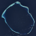 Runit Island is part of the Enewetak Atoll
 -
 In 1952, the United States dropped the nuclear bomb Ivy King 610 m (2,000 feet) north of Runit Island.
 -
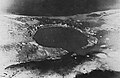 Crater created by detonation on 5 May 1958 (Operation Hardtack I, Cactus test)


References
[modifica | modifica wikitesto]- ^ Emma Reynolds. "Deadly dome of gorgeous Pacific island leaking radioactive waste", news.com.au, 7 July 2015. Retrieved 12 May 2017.
- ^ Jan Hendrik Hinzel, Coleen Jose and Kim Wall. "Climate change threatens radioactive storage dome in south Pacific – video", The Guardian, 3 July 2015. Retrieved 27 July 2016.
- ^ Visual Description of the Concrete Exterior of the Cactus Crater Containment Structure LLNL-TR-648143
[[Category:Enewetak Atoll]] [[Category:American nuclear test sites]] [[Category:Islands of the Marshall Islands]]