


Dimensioni di questa anteprima: 800 × 460 pixel. Altre risoluzioni: 320 × 184 pixel | 640 × 368 pixel | 1 024 × 588 pixel | 1 280 × 735 pixel | 2 560 × 1 471 pixel | 3 573 × 2 053 pixel.
File originale (3 573 × 2 053 pixel, dimensione del file: 2,02 MB, tipo MIME: image/jpeg)
| Questo file e la sua pagina di descrizione (discussione · modifica) si trovano su Wikimedia Commons (?) |
Dettagli
| Descrizione |
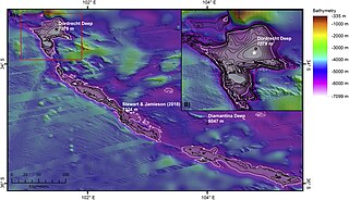
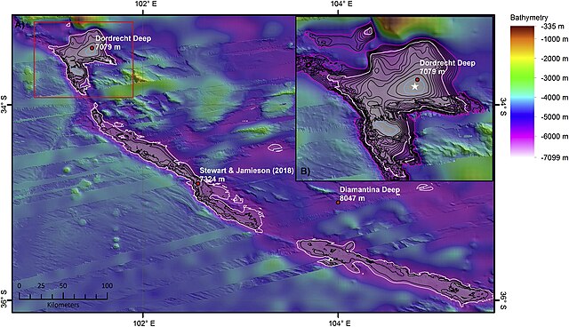
English: Map of the deepest section of the Diamantina Fracture Zone with the locations of published ‘deeps’ (red circles) (Table 1). The 6000 m depth contour is shown in white. The deepest section of the feature is defined by the 7000 m contour (blue). All other contours at 200 m intervals (between 6000 and 7000 m water depth) (B) Inset map of Dordrecht Deep with the deepest point determined during this study (white star = between 7090 and 7100 m water depth) which is within 4 km of the published GEBCO Gazetteer location for Dordrecht Deep. The outer rim of Dordrecht deep lies at 5300 m water depth (pink contour). The 7000 m contour is coloured blue. All other contours at 100 m intervals (between 5300 and 7000 m water depth). For location of inset map see the red box in Fig. 5A. Illumination from 45° at an altitude of 25°. |
| Data | |
| Fonte | Heather A. Stewart, Alan J. Jamieson: The five deeps: The location and depth of the deepest place in each of the world's oceans. In: Earth-Science Reviews 197, Oktober 2019, 102896, doi:10.1016/j.earscirev.2019.102896. |
| Autore | Heather A. Stewart, Alan J. Jamieson |
| Licenza (Riusare questo file) |
This is an open access article under the CC BY license (https://creativecommons.org/licenses/BY/4.0/). |

Licenza
Questo file è disponibile in base alla licenza Creative Commons Attribuzione 4.0 Internazionale
- Tu sei libero:
- di condividere – di copiare, distribuire e trasmettere quest'opera
- di modificare – di adattare l'opera
- Alle seguenti condizioni:
- attribuzione – Devi fornire i crediti appropriati, un collegamento alla licenza e indicare se sono state apportate modifiche. Puoi farlo in qualsiasi modo ragionevole, ma non in alcun modo che suggerisca che il licenziante approvi te o il tuo uso.
Cronologia del file
Fare clic su un gruppo data/ora per vedere il file come si presentava nel momento indicato.
| Data/Ora | Miniatura | Dimensioni | Utente | Commento | |
|---|---|---|---|---|---|
| attuale | 23:25, 12 mag 2020 | | 3 573 × 2 053 (2,02 MB) | Jean-Hyacinthe | {{Information |description ={{en|1=Map of the deepest section of the Diamantina Fracture Zone with the locations of published ‘deeps’ (red circles) (Table 1). The 6000 m depth contour is shown in white. The deepest section of the feature is defined by the 7000 m contour (blue). All other contours at 200 m intervals (between 6000 and 7000 m water depth) (B) Inset map of Dordrecht Deep with the deepest point determined during this study (white star = between 7090 and 7100 m water depth) which... |
Pagine che usano questo file
Le seguenti 2 pagine usano questo file:
Utilizzo globale del file
Anche i seguenti wiki usano questo file:
- Usato nelle seguenti pagine di de.wikipedia.org:
- Usato nelle seguenti pagine di en.wikipedia.org:
- Usato nelle seguenti pagine di www.wikidata.org: