Technopedia Center
PMB University Brochure
Faculty of Engineering and Computer Science
S1 Informatics S1 Information Systems S1 Information Technology S1 Computer Engineering S1 Electrical Engineering S1 Civil Engineering

faculty of Economics and Business
S1 Management S1 Accountancy

Faculty of Letters and Educational Sciences
S1 English literature S1 English language education S1 Mathematics education S1 Sports Education
teknopedia

teknopedia

teknopedia

teknopedia

teknopedia

teknopedia
teknopedia
teknopedia
teknopedia
teknopedia
teknopedia
  • Registerasi
  • Brosur UTI
  • Kip Scholarship Information
  • Performance
  1. Weltenzyklopädie
  2. File:Satellitenfotos des japanischen Katastrophengebietes nach dem Tsunami 2011.jpg - Teknopedia
File:Satellitenfotos des japanischen Katastrophengebietes nach dem Tsunami 2011.jpg - Teknopedia
  • File
  • Cronologia del file
  • Pagine che usano questo file
  • Utilizzo globale del file
  • Metadati
File:Satellitenfotos des japanischen Katastrophengebietes nach dem Tsunami 2011.jpg
Dimensioni di questa anteprima: 800 × 450 pixel. Altre risoluzioni: 320 × 180 pixel | 640 × 360 pixel | 1 024 × 576 pixel | 1 418 × 798 pixel.

File originale (1 418 × 798 pixel, dimensione del file: 1,08 MB, tipo MIME: image/jpeg)

Logo di Commons
Logo di Commons
Questo file e la sua pagina di descrizione (discussione · modifica) si trovano su Wikimedia Commons (?)

Dettagli

DescrizioneSatellitenfotos des japanischen Katastrophengebietes nach dem Tsunami 2011.jpg
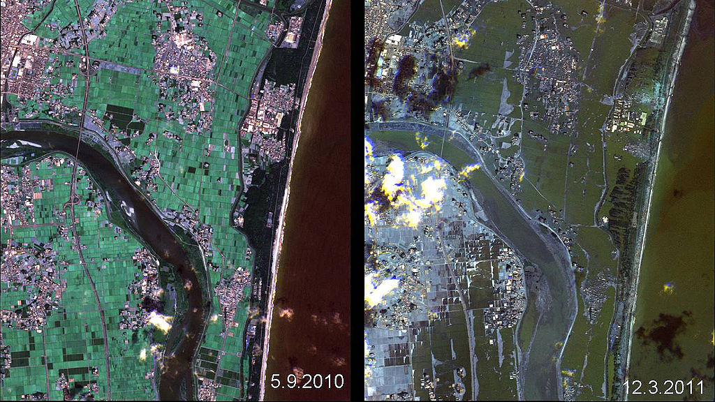
Deutsch: Das Bild zeigt Satellitenaufnahmen desselben Küstenabschnitts in Japan am 5 settembre 2010 und am 12 marzo 2011 in dem zerstörte Siedlungen durch den Tsunami des Tōhoku-Erdbeben erkennbar sind.
English: The picture show the same region from japanese coast twice. The first shot was created on 5 settembre 2010, the second on 12 marzo 2011. You can see destroyed settlements, caused by the tsunami from the Tōhoku earthquake.
Data 5 settembre 2010 e 12 marzo 2011
date QS:P,+2010-00-00T00:00:00Z/8,P580,+2010-09-05T00:00:00Z/11,P582,+2011-03-12T00:00:00Z/11
Fonte http://www.dlr.de/dlr/desktopdefault.aspx/tabid-10460/685_read-759/year-all/
Autore
Deutsch: Deutsches Zentrum für Luft- und Raumfahrt, Rapid Eye
English: German Aerospace Center, Rapid Eye

Licenza

This media has been released under a free license by the Deutsches Zentrum für Luft- und Raumfahrt (DLR).
Their website states: "Where expressly stated, DLR images and videos are covered by a Creative Commons Attribution 3.0 Germany (CC BY 3.0) licence. This licence grants permission to reproduce or distribute the work, to make the work and/or its contents publically available, to alter or edit the work and/or its contents and to make commercial use of the work, provided that you explicitly mention DLR as its source in a clearly legible format. Examples: 'Photo: DLR, CC-BY 3.0', 'Images: DLR, CC-BY 3.0', 'Video: DLR, CC-BY 3.0'."
To the uploader: You must provide a link (URL) to the original file and the authorship information if available.
w:it:Creative Commons
attribuzione
Questo file è disponibile in base alla licenza Creative Commons Attribuzione 3.0 Germania.
Attribuzione: DLR, CC-BY 3.0
Tu sei libero:
  • di condividere – di copiare, distribuire e trasmettere quest'opera
  • di modificare – di adattare l'opera
Alle seguenti condizioni:
  • attribuzione – Devi fornire i crediti appropriati, un collegamento alla licenza e indicare se sono state apportate modifiche. Puoi farlo in qualsiasi modo ragionevole, ma non in alcun modo che suggerisca che il licenziante approvi te o il tuo uso.
https://creativecommons.org/licenses/by/3.0/de/deed.enCC BY 3.0 deCreative Commons Attribution 3.0 detruetrue

Didascalie

Aggiungi una brevissima spiegazione di ciò che questo file rappresenta
Fukushima nuclear accident
Nuklearkatastrophe von Fukushima

Elementi ritratti in questo file

raffigura

disastro di Fukushima Dai-ichi

stato del copyright

coperto da diritti d'autore

licenza

Creative Commons Attribution 3.0 Germany inglese

Cronologia del file

Fare clic su un gruppo data/ora per vedere il file come si presentava nel momento indicato.

Data/OraMiniaturaDimensioniUtenteCommento
attuale21:22, 28 apr 2012Miniatura della versione delle 21:22, 28 apr 20121 418 × 798 (1,08 MB)Jotpe

Pagine che usano questo file

La seguente pagina usa questo file:

  • Incidente nucleare di Fukushima Dai-ichi

Utilizzo globale del file

Anche i seguenti wiki usano questo file:

  • Usato nelle seguenti pagine di de.wikipedia.org:
    • Iwanuma
    • Tōhoku-Erdbeben 2011
    • Nuklearkatastrophe von Fukushima
    • Watari (Miyagi)

Metadati

Questo file contiene informazioni aggiuntive, probabilmente aggiunte dalla fotocamera o dallo scanner usati per crearlo o digitalizzarlo. Se il file è stato modificato, alcuni dettagli potrebbero non corrispondere alla realtà.

OrientamentoNormale
Risoluzione orizzontale150 punti per pollice (dpi)
Risoluzione verticale150 punti per pollice (dpi)
SoftwareAdobe Photoshop CS3 Windows
Data e ora di modifica del file09:10, 12 mag 2011
Spazio dei coloriNon calibrato
Larghezza immagine1 418 px
Altezza immagine798 px
Data e ora di digitalizzazione11:10, 12 mag 2011
Data in cui i metadata sono stati modificati l'ultima volta11:10, 12 mag 2011
Versione IIM115
Estratto da "https://it.wikipedia.org/wiki/File:Satellitenfotos_des_japanischen_Katastrophengebietes_nach_dem_Tsunami_2011.jpg"

  • Indonesia
  • English
  • Français
  • 日本語
  • Deutsch
  • Italiano
  • Español
  • Русский
  • فارسی
  • Polski
  • 中文
  • Nederlands
  • Português
  • العربية
Pusat Layanan

UNIVERSITAS TEKNOKRAT INDONESIA | ASEAN's Best Private University
Jl. ZA. Pagar Alam No.9 -11, Labuhan Ratu, Kec. Kedaton, Kota Bandar Lampung, Lampung 35132
Phone: (0721) 702022