


Dimensioni di questa anteprima PNG per questo file SVG: 679 × 600 pixel. Altre risoluzioni: 272 × 240 pixel | 544 × 480 pixel | 870 × 768 pixel | 1 160 × 1 024 pixel | 2 319 × 2 048 pixel | 718 × 634 pixel.
File originale (file in formato SVG, dimensioni nominali 718 × 634 pixel, dimensione del file: 76 KB)
| Questo file e la sua pagina di descrizione (discussione · modifica) si trovano su Wikimedia Commons (?) |
Dettagli
| Descrizione |
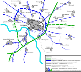
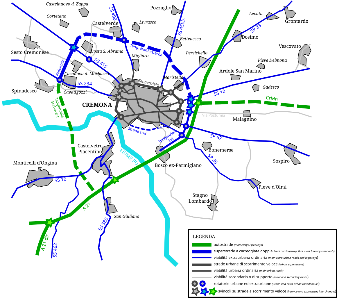
English: Map of roads, expressways and freeways in the city of Cremona and its suburbs. Continuous tracks are road and highways that were completed and open to public traffic before march 15th, 2008; dashed tracks are roads and highways that are currently under construction or just projected. Italiano: Mappa delle principali strade, superstrade ed autostrade dell'area suburbana di Cremona. I tracciati continui sono strade e autostrade completate prima del 15 marzo 2008; i tracciati tratteggiati sono strade e autostrade che sono attualmente in costruzione o solamente allo stadio di progetto. Lombard: Cartìna de le strade e de le autostrade atùrnu a la citàa de Cremuna. Le strade che le era bèle vèrte al 15 de Mars del 2008 i'è segnade cun la linea continua, le strade en custrüsiòon u 'nduma prugetade i'è segnade cun la linea trategiàda. |
| Fonte | Opera propria |
| Autore | Grasso83 |
Licenza
Io, detentore del copyright su quest'opera, dichiaro di pubblicarla con la seguente licenza:
Questo file è disponibile in base alla licenza Creative Commons Attribuzione-Condividi allo stesso modo 3.0 Unported
- Tu sei libero:
- di condividere – di copiare, distribuire e trasmettere quest'opera
- di modificare – di adattare l'opera
- Alle seguenti condizioni:
- attribuzione – Devi fornire i crediti appropriati, un collegamento alla licenza e indicare se sono state apportate modifiche. Puoi farlo in qualsiasi modo ragionevole, ma non in alcun modo che suggerisca che il licenziante approvi te o il tuo uso.
- condividi allo stesso modo – Se remixi, trasformi o sviluppi il materiale, devi distribuire i tuoi contributi in base alla stessa licenza o compatibile all'originale.
Cronologia del file
Fare clic su un gruppo data/ora per vedere il file come si presentava nel momento indicato.
| Data/Ora | Miniatura | Dimensioni | Utente | Commento | |
|---|---|---|---|---|---|
| attuale | 18:39, 1 mar 2008 | | 718 × 634 (76 KB) | Grasso83 | == Summary == {{Information |Description={{en|Map of roads, expressways and freeways in the city of Cremona and its suburbs. Continuous tracks are road and highways that were completed and open to public traffic before march 15th, 2008; dashed tracks |
| 18:37, 1 mar 2008 |  | 718 × 634 (86 KB) | Grasso83 | == Summary == {{Information |Description={{en|Map of roads, expressways and freeways in the city of Cremona and its suburbs. Continuous tracks are road and highways that were completed and open to public traffic before march 15th, 2008; dashed tracks | |
| 18:32, 1 mar 2008 |  | 744 × 1 052 (76 KB) | Grasso83 | {{Information |Description={{en|Map of roads, expressways and freeways in the city of Cremona and its suburbs. Continuous tracks are road and highways that were completed and open to public traffic before march 15th, 2008; dashed tracks are roads and |
Pagine che usano questo file
La seguente pagina usa questo file:
Utilizzo globale del file
Anche i seguenti wiki usano questo file:
- Usato nelle seguenti pagine di lmo.wikipedia.org:
Estratto da "https://it.wikipedia.org/wiki/File:Cremona_road_map.svg"