


Dimensioni di questa anteprima: 645 × 599 pixel. Altre risoluzioni: 258 × 240 pixel | 517 × 480 pixel | 827 × 768 pixel | 1 102 × 1 024 pixel | 2 204 × 2 048 pixel | 3 486 × 3 239 pixel.
File originale (3 486 × 3 239 pixel, dimensione del file: 1,89 MB, tipo MIME: image/jpeg)
| Questo file e la sua pagina di descrizione (discussione · modifica) si trovano su Wikimedia Commons (?) |
| Descrizione |
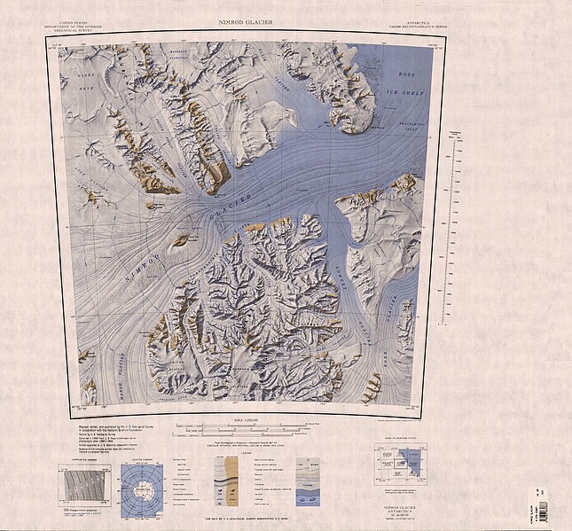
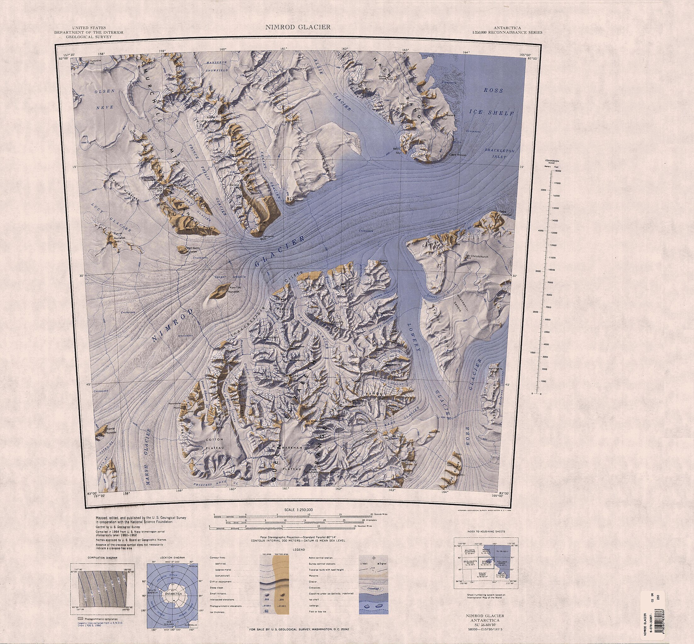
English: Map of Antarctica by the United States Antarctic Resource Center of the US Geological Society. |
| Fonte | USGS |
| Autore | USGS |
Quest'immagine è nel pubblico dominio perché contiene materiale proveniente dallo United States Geological Survey, un'agenzia del Dipartimento degli Interni degli Stati Uniti. Per maggiori informazioni vedere la politica ufficiale dell'USGS sul copyright.
|
Cronologia del file
Fare clic su un gruppo data/ora per vedere il file come si presentava nel momento indicato.
| Data/Ora | Miniatura | Dimensioni | Utente | Commento | |
|---|---|---|---|---|---|
| attuale | 14:43, 4 apr 2005 | | 3 486 × 3 239 (1,89 MB) | Achim Raschka | Map of Antarctica by the United States Antarctic Ressource Center of the US Geological Society. {{PD-US}} Copyrights and Trademarks USGS-authored or produced data and information are in the public domain. While the content of most USGS web pages is in th |
| 14:24, 4 apr 2005 |  | 3 486 × 3 239 (1,89 MB) | Achim Raschka | Map of Antarctica by the United States Antarctic Ressource Center of the US Geological Society. {{PD-US}} Copyrights and Trademarks USGS-authored or produced data and information are in the public domain. While the content of most USGS web pages is in th |
Pagine che usano questo file
Le seguenti 30 pagine usano questo file:
- Altopiano di Cotton
- Altopiano di Markham
- Dorsale Cobham
- Dorsale Holyoake
- Ghiacciaio Algie
- Ghiacciaio DeBreuck
- Ghiacciaio Dorrer
- Ghiacciaio Doss
- Ghiacciaio Errante
- Ghiacciaio Gray
- Ghiacciaio Hamilton (costa di Shackleton)
- Ghiacciaio Heidemann
- Ghiacciaio Heilman
- Ghiacciaio Kent
- Ghiacciaio Lowery
- Ghiacciaio Lucy
- Ghiacciaio Nimrod
- Ghiacciaio Nottarp
- Ghiacciaio Oliver (Dipendenza di Ross)
- Ghiacciaio Otago
- Ghiacciaio Pavlak
- Ghiacciaio Rowland
- Ghiacciaio Tranter
- Ghiacciaio del Principe Edoardo
- Ghiacciaio del Principe Filippo
- Ghiacciaio del Principe di Galles
- Insenatura di Shackleton
- Monte Markham
- Monti Churchill
- Monti della Regina Elisabetta
Utilizzo globale del file
Anche i seguenti wiki usano questo file:
- Usato nelle seguenti pagine di bg.wikipedia.org:
- Usato nelle seguenti pagine di ceb.wikipedia.org:
- Usato nelle seguenti pagine di de.wikipedia.org:
- Queen Elizabeth Range
- Robb-Gletscher
- Nimrod-Gletscher
- Lowery-Gletscher
- Miller Range
- Churchill Mountains
- Lucy-Gletscher
- Holyoake Range
- Prinz-Philip-Gletscher
- Cobham Range
- Astro-Gletscher
- Mansergh-Schneefeld
- Otago-Gletscher
- Hamilton-Gletscher (Queen Elizabeth Range)
- Markham-Plateau
- Campbell Hills
- Chappell-Nunatakker
- Cooper-Eisfälle
- Kon-Tiki-Nunatak
- Corner-Nunatak
- Cotton-Plateau
- Heidemann-Gletscher
- Nottarp-Gletscher
- DeBreuck-Gletscher
- Kent-Gletscher
- Dorrer-Gletscher
- Mount Heiser
- Frustration Ridge (Churchill Mountains)
- Gargoyle Ridge
- Tarakanov Ridge
- Hochstein Ridge
- Prinz-Edward-Gletscher
- Prince-of-Wales-Gletscher
- Half Dome Nunatak
- Mount Hofmann
- Inaccessible Cliffs
- Mount Katsufrakis
- Lyttelton Peak
- Prinzessin-Anne-Gletscher
- Olson-Firnfeld
- The Palisades (Antarktika)
- Panorama Point (Antarktika)
- Schroeder Peak
- Turret Nunatak
Visualizza l'utilizzo globale di questo file.