


Dimensioni di questa anteprima: 800 × 426 pixel. Altre risoluzioni: 320 × 170 pixel | 640 × 341 pixel | 1 024 × 545 pixel | 1 881 × 1 002 pixel.
File originale (1 881 × 1 002 pixel, dimensione del file: 429 KB, tipo MIME: image/png)
| Questo file e la sua pagina di descrizione (discussione · modifica) si trovano su Wikimedia Commons (?) |
Dettagli
| Descrizione |
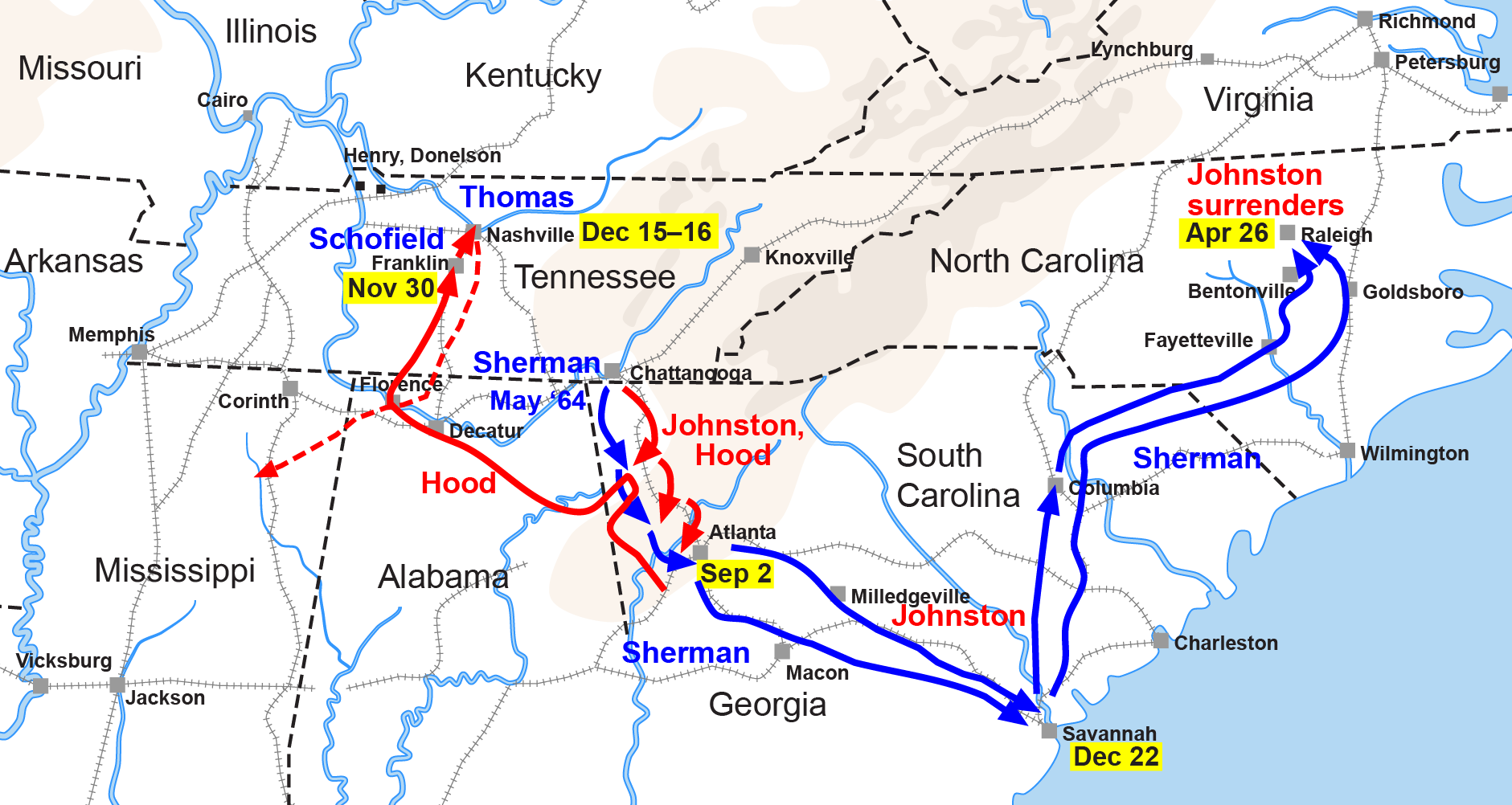
English: Map of the Western Theater of the American Civil War, actions from Chattanooga to the Carolinas. |
| Data | |
| Fonte | Drawn by Hal Jespersen in Adobe Illustrator CS5. Graphic source file is available at http://www.posix.com/CWmaps/ |
| Autore | Hlj di Teknopedia in inglese |
| Altre versioni |
|


Licenza
Questo file è disponibile in base alla licenza Creative Commons Attribuzione 3.0 Unported
Attribuzione: Map by Hal Jespersen, www.posix.com/CW
- Tu sei libero:
- di condividere – di copiare, distribuire e trasmettere quest'opera
- di modificare – di adattare l'opera
- Alle seguenti condizioni:
- attribuzione – Devi fornire i crediti appropriati, un collegamento alla licenza e indicare se sono state apportate modifiche. Puoi farlo in qualsiasi modo ragionevole, ma non in alcun modo che suggerisca che il licenziante approvi te o il tuo uso.
Registro originale del caricamento
Trasferito da it.wikipedia su Commons da MaEr.
La pagina di descrizione originale era qui. Tutti i nomi utente che seguono sono riferiti a it.wikipedia.
- 2006-10-06 17:12 Starlight 1566×773×??? (316548 bytes) Map of the Western Theater of the American Civil War, actions from Chattanooga to the Carolinas. Drawn by Hal Jespersen in Macromedia Freehand. Graphic source file is available at http://www.posix.com/CWmaps/ {{PD}}
La pagina di descrizione originale era qui. Tutti i nomi utente che seguono sono riferiti a en.wikipedia.
- 2006-03-31 00:30 Hlj 1566×773× (316548 bytes) Map of the [[Western Theater of the American Civil War]], actions from Chattanooga to the Carolinas. Drawn by Hal Jespersen in Macromedia Freehand. Graphic source file is available at http://www.posix.com/CWmaps/ {{PD-release}}
Cronologia del file
Fare clic su un gruppo data/ora per vedere il file come si presentava nel momento indicato.
| Data/Ora | Miniatura | Dimensioni | Utente | Commento | |
|---|---|---|---|---|---|
| attuale | 00:35, 25 mar 2011 | | 1 881 × 1 002 (429 KB) | Hlj | Update to new graphical style for rivers. Same license. |
| 07:34, 6 feb 2009 |  | 1 862 × 992 (309 KB) | Hlj | {{Information |Description=Map of Sherman's operations from Chattanooga through the Carolinas of the American Civil War. (Minor updates from previous version; new license.) Drawn in Adobe Illustrator CS3 by Hal Jespersen. Graphic source file is availa | |
| 13:50, 14 set 2008 |  | 1 566 × 773 (309 KB) | MaEr | {{Information |Description={{en|Map of the Western Theater of the American Civil War, actions from Chattanooga to the Carolinas. Drawn by Hal Jespersen in Macromedia Freehand. Graphic source file is available at http://www.posix.com/CWmaps/}} |Source=Tran |
Pagine che usano questo file
Le seguenti 3 pagine usano questo file:
Utilizzo globale del file
Anche i seguenti wiki usano questo file:
- Usato nelle seguenti pagine di en.wikipedia.org:
- Usato nelle seguenti pagine di fr.wikipedia.org:
- Usato nelle seguenti pagine di ja.wikipedia.org:
- Usato nelle seguenti pagine di ru.wikipedia.org:
- Usato nelle seguenti pagine di uk.wikipedia.org: